Skip to content

+65 6703 6930 | [email protected]

GeoInstinct LogoGeoInstinct LogoGeoInstinct Logo
  • Company
    • About
    • Meet the Team
    • Our Equipment
    • Our Software
    • Our Partners
  • Services
    • Assets
      • Asset Tagging
    • Geodetic
      • Control Networks
      • Construction Survey & Setting Out
      • Construction Verification
      • Floor Flatness Surveys
      • Measured Building Surveys
      • Topographical Surveys
      • Stockpile & Volume Surveys
    • Geophysical
      • Gravity Surveys
      • Magnetic Surveys
      • Soil Resistivity Testing
    • Geotechnical
    • Hydrographic
    • Inspection
      • Concrete & Rebar Scanning
      • Wind Turbine Inspection
    • Mapping
      • Airborne Survey
      • Mobile Mapping
      • Underground Utility Mapping
    • Metrology
      • Alignment & Levelling Services
      • Deformation & Surface Analysis
      • Laser Tracker Measurements
      • Measurement Arm Services
      • Reverse Engineering Services
    • Monitoring
      • Environmental Monitoring
      • Geotechnical Monitoring
      • Structural Monitoring
    • Reality Capture
      • BWTS Scanning
      • Laser Scanning
      • Scan-to-BIM
      • Scan-to-EAM
      • Scan-to-Plan
    • Specialist
      • Gyroscopic Surveys
      • Rail Surveys
    • Utilities
      • CCTV Drainage Surveys
      • Ground Penetrating Radar Surveys
      • Line and Level Surveys
      • Manhole Surveys
  • Consultancy
    Digital Consultancy
    • Digital Surveying and Reality Capture
    • Digital Twins
    • Geospatial Information Management
    • Industry 4.0
    • Smart Asset Management
    • Smart Cities
    • Smart Enterprise Management
    • Smart Facilities Management
    Strategic Consultancy
    • BIM Education and Training
    • BIM Strategy, Performance, Protocols and Procedures
    • Compliance and Assurance
    • Construction Forensics
    • Industrial Cyber Security
    • Management Consulting
    • Organisational Digital Transformation
    • Whole Lifecycle Project Management
    Virtual Design & Construction
    • Artificial Intelligence and Machine Learning
    • As-Built Construction Verification
    • Augmented Worker
    • Automated BIM Verification and Validation
    • Design for Off-Site Manufacture and Assembly
    • Enterprise Management Dashboards
    • Integrated Project Information Management
    • Predictive Scenario Modelling
    • Virtual, Augmented and Mixed Reality
    • Digital Consultancy
      • Digital Surveying and Reality Capture
      • Digital Twins
      • Geospatial Information Management
      • Industry 4.0
      • Smart Asset Management
      • Smart Cities
      • Smart Enterprise Management
      • Smart Facilities Management
    • Engineering Consultancy
    • Strategic Consultancy
      • BIM Education and Training
      • BIM Strategy, Performance, Protocols and Procedures
      • Compliance and Assurance
      • Construction Forensics
      • Industrial Cyber Security
      • Management Consulting
      • Organisational Digital Transformation
      • Whole Lifecycle Project Management
    • Virtual Design and Construction
      • Artificial Intelligence and Machine Learning
      • As-Built Construction Verification
      • Augmented Worker
      • Automated BIM Verification and Validation
      • Design for Off-Site Manufacture and Assembly
      • Enterprise Management Dashboards
      • Integrated Project Information Management
      • Predictive Scenario Modelling
      • Virtual, Augmented and Mixed Reality
  • News
Home » コンサルティング » バーチャル設計・施工 » 統合プロジェクト情報管理

統合プロジェクト情報管理

GeoInstinctは、従来の手法を阻む固有の問題を可視化、分析、解決するためにクライアントをサポートします。 私たちのソリューションは、ライブエンジニアリングデータの動的解析に焦点を当て、非構造化データの構造化の自動化を可能にします。

統合プロジェクト情報管理Webmaster2023-05-07T18:27:05+07:00
  • Risk Management
  • Solution
  • Benefits

リスクマネジメント

建設・据付作業に伴うリスクは、プロジェクトのプログラムや計画に大きな影響を与える。 現在のシーケンスソリューションは理想的なシナリオに基づいていますが、プログラムの変動に対応し、発生した問題に対応するための確固たるプロセスやソリューションがありません。

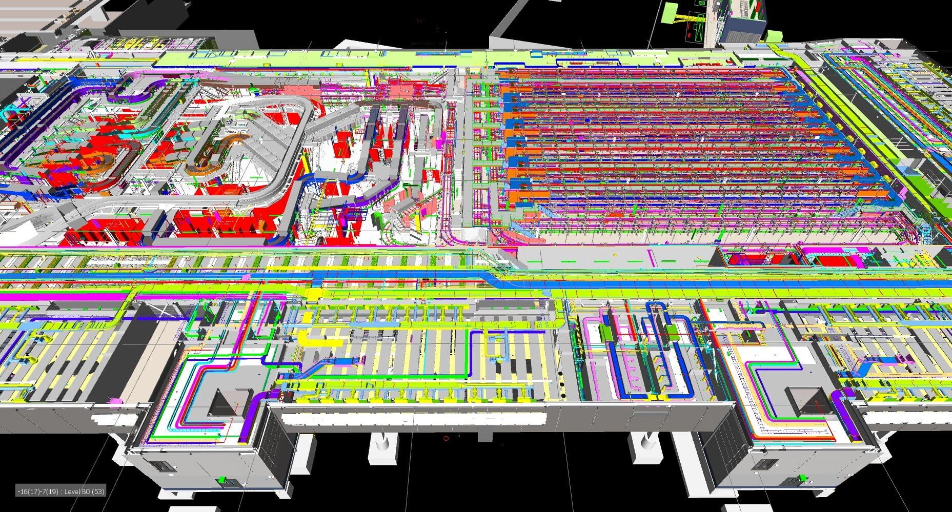
データソースを集約し、連続するアクティビティの詳細な分析をサポートする一方で、他のアクティビティによって引き起こされる制約や影響を視覚化する能力を持つことで、プロジェクトアクティビティに対する強力で予測的な洞察を提供します。
ソリューション

私たちのソリューションは、従来の方法を阻む固有の問題を可視化、分析、解決するために開発されました。

私たちのソリューションは、ライブエンジニアリングデータの動的解析に焦点を当て、非構造化データの構造化の自動化を可能にします。 そこから、さまざまなデータソースを集約し、潜在的な問題が重大化するはるか前に、可視化することができるのです。 現在の方法では、遅延や影響が発生したときにしか気づくことができないため、これはソリューションの成功に不可欠な要素です。

予測出力は、事象が発生する前の管理、緩和、削減を可能にします。 ラストプランナーのコンセプトである「ワークアブル・バックログ」を実現することで、コントラクターが計画した活動に問題が発生した場合、他の分野に努力を移すことができる。

メリット

構造化データを1つのプロジェクト情報管理ツールに統合することで、従来のツールの制約を緩和し、以下のメリットを活用することができます:

  • 課題、リスク、ホットスポットを可視化し、特定する。
  • 3Dで使えるアウトプットを生成する
  • アクセス、レイダウン、仮設作業活動の管理
  • 既存データの構造化・集約化、相互運用性の向上
  • ロジスティクス活動を動的に分析する
  • オプショナルツアーと計画外の変化への対応
  • 物流・仮設工事オーバーレイ

Contact Us

Call Us

+84 (0) 28 710 99 369

Email Us

[email protected]

Client Hub

  • GeoInstinct Access
  • GeoInstinct Assist
  • GeoInstinct Books
  • GeoInstinct Cloud
  • GeoInstinct Cyclone
  • GeoInstinct Projects
  • GeoInstinct Status
  • GeoInstinct Support

About Us

  • About
  • Our Equipment
  • Our Software
  • Our Partners
  • Events
  • News
  • Meet the Team
  • Careers

Legal

  • Privacy Policy
  • Terms & Conditions
  • Service Commitment

Vietnam

GeoInstinct Vietnam Co. Ltd.

MST: 0314818251

11A Dong Da, Ward 2, Tan Binh District, Ho Chi Minh City, Vietnam, 700000

Singapore

GeoInstinct Pte. Ltd.

UDN: 202328899R

68 Circular Road, #02-01, Singapore, 049422

Copyright © 2023, GeoInstinct Pty Ltd. All Rights Reserved.

Toggle Sliding Bar Area
Page load link
Go to Top