Objective
- To scan the entire building within a range of 10 – 30 mm accuracy.
- For fast scanning and with minimal cost.
- To have a dense point cloud from which to create construction plans.

Technology
- Use a GeoSLAM ZEB-REVO RT scanner and with only one operator to perform the surveying work for the whole building.
- The point cloud was registered in real time while surveying the building.
- Colors can be captured, but not required.

Survey
GeoInstinct visited the building in the morning and conducted an initial site survey, checked on access and implementation issues, and finally we found the building quite accessible and we could access most areas.
The GeoInstinct operator then set up the device and proceeded to scan the building starting from the ground floor, sweeping the basement then working on the top floor, making sure to have both stairs and lift areas.
In total, the scanning process takes 1 hour and 45 minutes, collecting more than 150 million points for a 15 floor building!
Point Clouds

Initial Results
The GeoInstinct team delivered the initial results immediately to reference customers, and then proceeded to work out more detailed results to extract survey features (such as cabling, lights and systems). fire fighting system) from the cloud.
(GeoSLAM Viewer, 9% of Captured Points)

Exporting Results
The point cloud is converted to PLY with 9% of the points displayed for use in CloudCompare and additional analysis.
(CloudCompare, 9% of Captured Points)
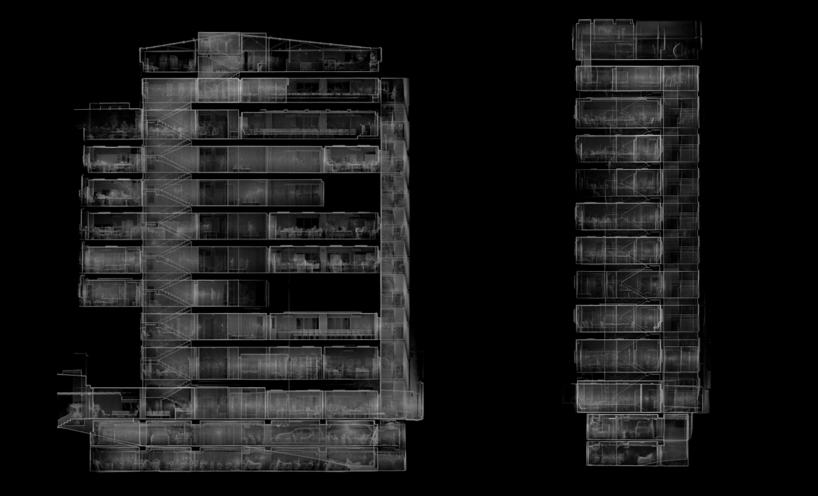
Section Views

The team used PointCab to quickly transform the 3D Point Cloud into 2D Package and View Parts of all floors, as well as to create building AutoCAD .dwg vector files.
(PointCab – Section Tool)
Layout Views

It took less than 1 hour to create all the correct floor plans and section views using the PointCab Part and Layout tool.
(PointCab – Layout Tool)
Floor Level Analysis

The level of the floor is particularly interested to determine if any arbitrage occurs since the construction is completed. The PointCab Delta tool was used to create a scale model, with each floor taking less than 30 seconds to analyze.
(PointCab – Delta Tool)
Meshing

To extract details from the point cloud, a grid pattern is created from the ground floor to level 1 staircases, something that is hard to do otherwise. PointCab Mesh tool has been used to achieve this with the whole case of stairs being extracted in minutes.
(PointCab – Mesh Tool)
CAD

Scaled Drawings
The technician has also used PointCab to create DWG files for AutoCAD, containing scaled raster images of buildings for use in tracking and combining drawings.

As-Built Documentation
Using the SLAM scanner means we can quickly gather enough data to create floor plans, but in Autodesk Recap with Autodesk AutoCAD, this is very difficult, so the team used the tool Vectoriser from PointCab to automatically create vector lines to use in PointCab, with each floor taking less than 5 minutes to complete.
(PointCab – Vectoriser Tool)
Construction Verification

To compare models, raster images are exported in black and white from PointCab to AutoCAD, in which the original CAD plans were overlaid to test the plans.
(AutoCAD combined với xuất phần View from PointCab)
Results
In total, the scan took less than 2 hours, producing the 2D plans took less than 2 hours and the initial BIM model was completed in less than a day.
Comparisons
- 10 times faster than ground laser scanning
- 100 times faster than traditional survey
- Results are registered in real time allowing immediate delivery of initial results
Generated Data
- 3D point cloud of the building
- 2D plans and sections of each floor
- AutoCAD Vector package of all floors
- Revit model of the building
- PointCab file for Documents and Processing